
VVMapping.com - providing high quality mapping products for outdoor recreation
|
ORV Trail Maps
|
Maps for your GPS Great Lakes ORV GPS Maps - ORV Trail Systems in Michigan, Minnesota, South Dakota & Wisconsin Version
2026.5.25 (5/25/26)
is available for $55 (price includes tax and
shipping).
Included in package price:
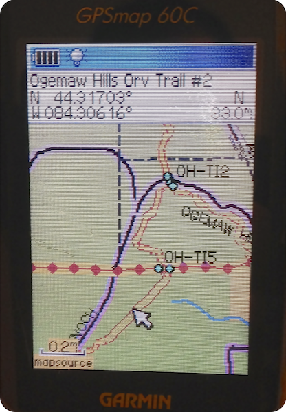
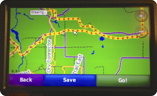
Complete Coverage for Michigan and Wisconsin and Minnesota and South Dakota. Full road coverage, rivers, lakes, towns and more. Points of interest, parking lots, lodging, gas stations. Public Land is shown including State Forests, county forests, national forests, Parks, Wildlife Mangement Areas, public hunting areas and related including commercial forest land. Includes current Motor Vehicle Use Map data to help you identify open/legal roads on National Forest lands. Includes current Michigan DNR State Forest Road open/closed status for ORVs. Includes county roads designated as open to ORVs by ordinance. These maps visually show the different ORV Trail/ATV Trail, Motorcycle-Only Trail, Michigan Cross Country Cycle Trail, ORV Route/ATV Route, county road, county road open to ORV, highways, forest roads and more. Hundreds of miles of non-motorized trails plus snowmobile trails. Maps support routing in the computer and Garmin GPS. Makes trip planning simpler; have the GPS tell you how to get back to the parking lot with turn by turn directions. Automatic routing, as in "turn by turn" directions only on Garmin units. See our Routing FAQ. Maps come loaded on a memory card, just plug into your GPS and go, tablet setup requires app installation and configuration (app included on card). Map installer included on card can be used to put the maps on the computer which will integrate into an existing copy of Garmin's MapSource or BaseCamp software. View the maps on the big screen, plan your trips. Check out the additional map features including legend and sign guide or print our current Map Legend. This map, like most of ours, was developed by recording with a GPS unit while actually riding the trails and provides full coverage of the entire systems listed. System Requirements:
These maps only work with Garmin brand mapping GPS units as well as the larger Lowrance GPS models and also Android tablet with GPS and Card Slot, please see our list for specific model support and more information.
Please note: individual trails may be closed, renamed or rerouted at the discretion of the Trail Authority. If it's not signed on-the-ground, it may not be open. Questions? Please email us with your questions/suggestions.
|
Maps are updated throughout the year as new systems come online, trails are changed/closed/opened. Maps and installation program are loaded on the included memory card. To install the maps to your computer, the card will need to be connected to it either through the GPS or a card reader. If your computer does not have a card reader, we offer a USB card reader as an option. CDs are also optional. Also available is the combined Snowmobile and ORV trail system maps.
|
