VVMapping.com - providing high quality mapping products for outdoor recreation
|
|
Maps for your GPS GPS compatible maps of Michigan, Wisconsin, Minnesota, South Dakota and Indiana's ORV and Snowmobile Trail Systems. North Dakota now included in the Snowmobile Map. Version 2026.5.25 (5/25/26) is available for $85 (price includes tax and shipping).
Package includes the following:
This combo package saves $20 off purchasing the ORV and the Snowmobile maps separately. The pre-loaded card allows you to just install the card in your GPS and go. Overview of map features (Snow + ORV, separate Snow & ORV Sample) and as seen on the GPS Screen. Maps support routing in the computer and GPS. Makes trip planning simpler; have the GPS tell you how to get back to the parking lot with turn by turn directions. Automatic routing, as in "turn by turn" directions only on Garmin units. See our Routing FAQ. Covers all of Michigan, Wisconsin, Indiana and Minnesota in 1:24,000 detail. The Public Off-Road Vehicle Trail systems plus the Snowmobile Trail Systems are included in their entirety for each State. Each trail has been documented with a GPS unit, the most accurate product available.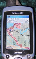
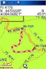
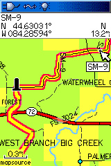
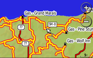
Now you can know where you are on the trail, where the parking lot is, which roads are near by and even which trail intersection is coming up. The trails and roads are "routable" enabling you to pick a destination and have the GPS guide you by trail to that point. This map installer is designed to integrate into an existing copy of Garmin's MapSource or BaseCamp, allowing you to interact with our maps, plan trips and send information back/forth with your GPS. There are two separate maps included. The Great Lakes Snowmobile has the Snowmobile trails as bright colors (use when on the sled) and the Great Lakes ORV have the ORV Trails as bright colors (use when on the bike/ATV/UTV). It is built on the most recent 1:24,000 scale data and includes highways, roads, water features and various points of interest. It also has public land data including State Parks, State Recreation Areas plus other County, State, USFS & Military land sections. The North Country Trail (hiking) is also included in addition to many other non-motorized trail systems. Includes complete forest road coverage for all of the National Forests in Michigan, Minnesota and Wisconsin, straight from their Motor Vehicle Use Map. National Forests include: Chequamegon-Nicolet, Ottawa, Hiawatha, Superior and Huron-Manistee. Visually identify open/legal roads on National Forest lands. Open/closed state forest roads in Michigan for both UP and LP. The ORV Trail System has several types of trails and roads available.
These maps visually show the different ORV Trail, Motorcycle-Only
Trail, Michigan Cross Country Cycle Trail and ORV Routes. Our online Help can assist with loading the maps to your computer/GPS and we are always glad to help over email or phone. System Requirements:
These maps only work with Garmin brand mapping GPS units as well as the larger Lowrance GPS models and also Android tablet with GPS and Card Slot, please see our list for specific model support and more information. Questions? Please email us with your questions/suggestions.
|
Help for downloading and installing the maps. Documentation(PDF) is also included. Version information for each release of this item. Please send us feedback! What would make this more useful, what type of GPS do you use, etc.
Mailing List - Be notified of updates |