VVMapping.com - providing high quality mapping products for outdoor recreation
|
|
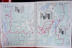
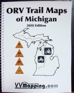
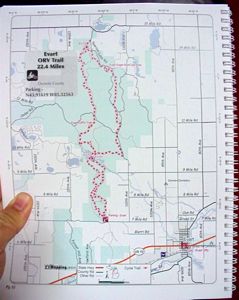
Printed Maps Michigan Motorcycle and ATV Trail Map Book Michigan's ORV Trail System Current Edition is available for $45 (price includes tax and shipping). Purchase it online now or use our mail-in Order Form. These books are constanty updated througout the riding season. No big pre-productions here, each book is created on-demand. Every page is focused on one trail or trail "system" if it's a group of trails. If you are a trail rider looking for the motorcycle-only and 50" ORV Trails, this is the book for you. If you are looking for the trails, Routes and also the open county and forest roads to use to connect trails and complete coverage of the State, our ORV Guide Book is the better choice. The Michigan Off-Road Vehicle Trail system is included in it's entirety. Both the upper and lower peninsula are covered. Over 3000 miles of trails! Even the connecting Michigan Cross Country Cycle Trails (MCCCT) trails. The MCCCT has it's own section of pages for those following that 600+ mile journey through the woods. Each trail has been documented with a GPS unit, more accurate than any other product we know of. Our online MI ORV Trail Guide is right from our older printed map book. You can download and print each page from that mapbook through our free online guide. Trails visually differentiated between ORV, Motorcycle-Only, ORV Route, county road vs open to ORV county road and more. Book is wire bound for convenience and durability.
Over 100 pages of full color detail. Size is 8.5" x 11" - easily take it on the trail with you! ORV Trails and Routes shown and easily identified. Type of ORV Trail listed, making it easy to see which trails are maintained for motorcycles and which are appropriate for ATVs and bigger. Sections that require more than an ORV Sticker clearly shown as well. Public land ownership is included. Certified county roads, state highways, forest roads and more. Parking lots are included, with GPS coordinates. Nearby gas stations and campgrounds. Distance between trail intersections, trail intersection numbers and more.
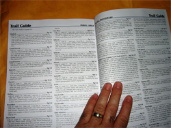
Details on ORV rules included. An integrated Trail Guide covers each trail. The Guide includes descriptions of each trail, local ORV ordinances (know if the county is "open" or not), which trails connect, which campgrounds are nearby and more!
This compliments our GPS ORV Trail Map product very nicely. Use the GPS to know exactly where you are and the mapbook for the "big picture". Questions? Please email us with your questions/suggestions. |
Download this sample page from the Map Book (PDF) Please send us feedback! What would make this more useful, what type of GPS do you use, etc.
Mailing List - Be notified of updates |